                         /\4000' SUMMITS
                    /\  //\\in the White Mountains,
             /\    //\\///\\\        /\the Adirondacks,
            //\\  ///\////\\\\  /\  //\\ Maine & Vermont
 /\        /  ^ \/^ ^/^  ^  ^ \/^ \/  ^ \
/ ^\  /\  / ^   /  ^/ ^ ^ ^   ^\ ^/  ^^  \
.::. MAINE & VERMONT.::.
4000' Peaks in MAINE
MOUNTAIN ELEV. DATE TRAILS SUMMIT BREW 1 KATAHDIN-Baxter Peak 5268' Sept 7, 2005 Chimney Pond,North Basin,Hamlin Ridge,NW Basin, Heel-On Taylor Oak Pond White Fox 2 KATAHDIN-Hamlin Peak 4756' Sept 7, 2005 Chimney Pond,North Basin,Hamlin Ridge,NW Basin, Heel-On Taylor 3 Sugarloaf 4250' 4 Old Speck 4170' 5 CROCKER-North Peak 4228' 6 BIGELOW-West Peak 4145' Sept 4, 2007 Fire Warden,Horns Pond,Bigelow Ridge Gritty's Halloween Ale 7 North Brother 4151' Sept 9, 2005 Marston Trail,Brother Trail Gritty's Oktoberfest 8 SADDLEBACK 4120' August 2, 2015 Grey Ghost Trail, Appalachian Trail Ipswich Route 101 IPA 9 BIGELOW-Avery Peak 4090' Sept 4, 2007 Fire Warden,Horns Pond,Bigelow Ridge Lagavulin Single Malt 10 Abraham 4050' 11 CROCKER-South Peak 4050' 12 SADDLEBACK-The Horn 4041' 13 Redington 4010' 14 Spaulding 4010'
South Brother 3960' Sept 9, 2005 Marston Trail, Brother Trail Coe 3764' Sept 9, 2005 Marston Trail, Brother Trail The Owl 3736' Sept 6, 2005 Hunt Trail to Owl Trail Oak Pond Oktoberfest South Turner 3122' Sept 8, 2005 Russell Pond, Sandy Stream, S. Turner Trail Shipyard Export BIGELOW: South Horn 3805' Sept 4, 2007 Fire Warden,Horns Pond,Bigelow Ridge BIGELOW: North Horn 3792' Sept 4, 2007 Fire Warden,Horns Pond,Bigelow Ridge AZISCOHOS 3215' Aug 2, 2016 Red Blaze trail Pamola Xtra Pale Ale BORESTONE MOUNTAIN 1923' June 9, 2018,August 17, 2020 Borestone Trail Sierra Nevada Hazy Little Thing BALD MOUNTAIN OQUOSSOC 2457' August 17, 2022 Bald Mountain Trail Portland Pale Ale
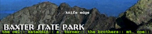
.:: 2005 KATAHDIN TRIP ::.
(September, 2005) BAXTER STATE PARK. KATAHDIN. KNIFE EDGE. Four perfect days in Baxter - the mountain gods smiled this year. Don't tell no-one, but apres-Memorial Day weekend seems pretty ideal. KATAHDIN is the finest mountain in the East. No question. A massive stand-alone mountain that dominates the Maine horizon. There is no easy ascent. Almost exactly a mile high. A majestic mutha of a mountain. And Knife Edge. Absotively nothing like it (in the East anyways.) And I gots my new portable tripod with me, so this has become one huge egotrip!
Started at Great Moose Pond, Q's Flatrock Inn matter of fact. The fishing wasn't the best, but the weather was. And the Quarter's got a fine selection of domestic brewskis. Slept under the stars for two nights. The skunk incident notwithstanding. A skunk with skahoonas like that gets free reign. That sucker walked right by me in my sleeping bag maybe three times without even flinching. I think he mighta given me the finger... Even Squauker (Quarter's cat) didn't dare mess. I slowly gathered up the bits of our barbeque (that Stinky hadn't already harvested) and hid them away. All the while thinking that getting sprayed could screw up the whole plan.
~Photos here!~
.:: The OWL (3736') ::.
DAY 1: (September 6, 2005) The OWL (3736').
Left Quarter's early, hit Baxter the crack o' noon. Talked with a ranger who pointed me towards the OWL. Left the Katahdin Stream Campgound on the Hunt (Appalachian) Trail, then the Owl Trail to the summit. Balancing Rock is a sight - a huge boulder sitting precariously on the edge of a cliff. Great cliffs on this mountain. An Oak Pond Oktoberfest was shared with the Owl. Spectacular hike - you find yourself planted between KATAHDIN and the BROTHERS, looking at KATAHDIN's slopes from the west. Into Witherle Ravine and the Abol Trail, a long slagheap I've schlepped up a coupla times, once with the Q-Tip. About 6.6 miles alltold. Quite the look-see. There's an 80-foot waterfall on the west face of KATAHDIN that could be a future hike.
.:: KATAHDIN (5267') ::.
DAY 2: (September 7, 2005) KATAHDIN (5267'). KNIFE EDGE. From the Roaring Brook Campground (my home for 4 days), took the Chimney Pond Trail to the North Basin Trail, visiting Basin Pond along the way. Took a little sidetrip to Blueberry Knoll, which afforded great views into the North Basin. And upward to HAMLIN PEAK (4751') via the Hamlin Ridge Trail. Dozens of ponds start appearing below, and the expanse of KATAHDIN and the South Basin are seen in all their glory. Northwest Basin Trail to Caribou Spring, one of several high mountain springs where I refilled my bottles. This area's known as the Tableland, the plateau on KATAHDIN that stretches for miles. The KNIFE EDGE was calling, getting closer, and it was on to BAXTER PEAK (5267') where a PB & honey and an Oak Pond White Fox were consumed in celebration. Here the KNIFE EDGE officially begins, but it really gets hairy beyond SOUTH PEAK (5240'). With a little wind kicking up, I was VERY focused. Achieve I haven't. The drop is sheer, and it's hand-over-foot climbing the rest of the way to PAMOLA (4902'). Exhilaratin'! Descending the Heel-on Taylor Trail completes the loop, about 12 miles including the little side trips. Loved every single moment of it.
.:: SOUTH TURNER (3122') ::.
DAY 3: (September 8, 2005) SOUTH TURNER (3122'). (Secured a lean-to on Roaring Brook so I can climb the Brothers tomorrow.) This was my easy day. Nature-Detective day, especially around Sandy Stream Pond. Many small creatures, 'specially buggage. Bad Baggage. Buggage. Footprints of larger critters.
The South Turner (3122') summit was swarming with some unidentified little beasties. And I mean SWARMIN'! Tagged the top an' hot-tailed it down a bit to a nice little crag and had a leisurely lunch of pepperoni & wheatbread and a Shipyard Export. Nice mountain, looking into the glacial cirque of KATAHDIN from the east. Really draggin' after some hard miles the last few days. Wandered about stalking several ponds for moose. To no avail. Excellent day nonetheless.
.:: The BROTHERS (4143' & 3960') Mt. COE (3764') ::.
DAY 4: (September 9, 2005) The BROTHERS: NORTH BROTHER (4143'). SOUTH BROTHER (3960'). MT. COE (3764'). From Slide Dam took the beautiful gorgeous Marston Trail to the Brother Trail. Northeast to North Brother (where you can bushwhack to Fort Mountain), backtracked to South Brother and Mt. Coe. Coming down Mt. Coe, wet, steep & slick, I slipped and hit the rockface hard. Sprained me wrist and wrenched me back. Then looped the loop via the Mt. Coe Trail to Marston. Perhaps the finest sculptured trail I've had the pleasure of walking upon.
.:: 2007 BIGELOW TRIP ::.
.:: BIGELOW: South Horn (3805') North Horn (3792') West Peak (4145') Avery Peak (4088') ::.
(September 4, 2007) Nice rugged mountain. Ridin' the ridge along the Appalachian Trail for several miles hitting the 4 peaks on Bigelow. (Two of them count, the others are nothing to me.) Took the Fire Warden Trail, the Horns Pond Trail to the Bigelow Ridge Trail (AT). Lookin' north at Flagstaff Lake and the Dead River, a legendary fishing spot according to the dude in the Liberal Pint Brewery.Much of the ridge trail is wooded until West Peak (4145') and Avery (4088'). Probably a good thing on this day as the wind was a whippin'. Not quite Katahdin or the Presidentials, maybe comparable to the Lincoln-Lafayette ridge. The views of Flagstaff Lake and the Dead River are just spectacular. Lotsa gain. Maybe 13-14 miles with the sidetrips. Great backpacking destination.
.:: 2015 ::.
.:: 2015 SADDLEBACK ::.
(August 2, 2015) On a perfect summer day, Jenny, Devo and I went up the Grey Ghost ski trail which eventually catches the Appalachian Trail to the summit of Saddleback. Views abound almost from the outset, with more and more opening up as you ascend. A short sweet way to the summit. Ride the saddle another 1˝ miles to the Horn, which I passed on as my companions were below. Anchors from some sort of structure on top, and amazing views of Rangeley Lake and countless others, as well as ripples of mountains. A keeper!
.:: 2016 ::.
.:: 2016 AZISCOHOS ::.
(August 2, 2016) Aziscohos Mountain affords some of the finest views in the Rangeley Lake area, it's summit was the former site of a fire tower that was mostly removed in 2004. Our first challenge (mountaineers were Jenny, Devo & JB) was finding the trailhead, near a logging road off ME16, a tricky proposition. The red-blazed trail, once found, is easily followed. About 4.2 miles roundtrip. The first mile slowly rises through beautiful forest, after which most of the 1550' of gain must be won.The summit is largely bare, a fire at some point, and the creation of the fire tower perhaps, and 360° views are stunning. Hundreds of mountains (we spotted Mt. Washington far off by it's summit storm) and 15 lakes are visible. Jenny & I found a fine blueberry patch and foraged. A worthy hike - short in miles but tough footing and some real gain. Strangest thing was the lack of wildlife. An occasional bird and a large toad were all we saw.
.:: 2018 ::.
.:: 2018 BORESTONE MOUNTAIN (1923') :.
(June 9, 2018) An Audubon site is always incredible, and Borestone is no exception. Climbing Borestone Mountain is short but sweet. About 2 miles each way with some pretty ponds, forest and amazing staired trail work. Elevation is 1923', but 962' gain. The last half-mile affords some worthy hand over foot climbing. I had sciatica issues so this was a tough one for me. Quarter was a mountain goat!
.:: 2020 ::.
.:: 2020 BORESTONE MOUNTAIN ::.
(August 17, 2020) Borestone Mountain, 1923', 962' gain, so some serious up. First mountaintop for me since Covid. Quarter and I climbed this in 2018 and love it. There are 3 spots up high with cast iron handholds embedded in the rock. Fantastic views throughout. Mountaineers up here were respectful of distance.
.:: 2022 ::.
.:: 2022 BALD MOUNTAIN (2457') ::.
(August 17, 2022) Bald Mountain (2457') is about 5 miles up and down. Devo & I hoofed to the summit,where there was a 4 story tower with views to die for. The White Mountains, Rangeley, Mooselookmeguntic Lake - just a fantastic view of an amazing area. Flat at the start, then maybe a mile in starts the climb! Some hand over foot, but not a whole lot. We talked with someone on the summit about 'Bang Fer Yer Buck' hikes, and this is one of 'em.
4000' Peaks in VERMONT
MOUNTAIN ELEV. DATE TRAILS SUMMIT BREW 1 Mansfield 4393' 2011 October 30 Eagles Cut, Sunset Ridge, Long Trail Fishbrook WetHop Simcoe Rye 2 Killington 4235' 2015 August 29 Bucklin, LongTrail, Killington Spur Ipswich Route 101 IPA 3 Camel's Hump 4083' 2011 October 29 Burrows Trail Fishbrook Amarillo Ale 4 Ellen 4083' 2012 June 17 Jerusalem Trail, Long Trail Hill Farmstead Edward Pale Ale 5 Abraham 4006' 2011 October 10 Battell Trail, Long Trail Fishbrook Amarillo Ale
Pico Peak 3957' 2015 August 30 Sherburne Pass Trail, Pico Link Lost Nation Mosaic IPA
/\
.::/1\::.
MOUNT MANSFIELD, Green Mountains VT (4393')
(October 30, 2011) Mount Mansfield, at 4393', is the highpoint in Vermont. I believe I summited this peak years ago, but nothing looked remotely familiar. Underhill State Park was closed for the season, so maybe an extra mile hike to the Eagle's Cut Trail. Took the Eagles Cut to the Sunset Ridge Trail. Icy evergreens on the Sunset Ridge Trail, rime ice in October. Who woulda thunk it. Winter conditions today, very icy trail and low visibility on the ascent. In miles (8.2) this trail was short, but one of the tougher hikes I've done, with the ice and 2550' elevation gain. Lotsa hand over foot scramblin' here, and much on ice. Near the summit, the Sunset Ridge Trail intersects the Long Trail. Somewhere around this point, I found a lost stabilicer. Made things MUCH easier. (Lost it myself twice along the way, and doubled back to recover it.) Probaly a tad under prepared for these conditions. DOH!
A view from Mansfield! Things started changing on descent. The whole feel changed very quickly, like a Jeff Beck solo. The JB mojo WAS workin', just not workin' for me. (Least not 30 minutes before when I stood on the summit.) But things opened up shortly after on my way down. Soon I knew I'd been blessed by the mountain gods when the horizons opened up - just amazing. Praise Big Eddy! Lake Champlain and the Daks appeared suddenly through the mist to the west.
Three (German?) folks I met nearing the summit bailed. Wearing sneakers but otherwise well dressed. Sneakers on ice: NEIN! They wisely turned back. Twas icy as hell. Another dude, with stabilicers, was goin' up, and his timing, I think, will have been perfect - it was totally clear an hour later. Gotta come clean here: the Fishbrook Simcoe Rye Ale was not imbibed on the summit. I was wary of the descent. But fear not - it paired well with a fine turkey-provolone sandwich from the Jericho General Store at trails end.
Seems the ski slopes are on the east in the Green Mountains, and being kinduva snooty mountaineer I'm not thrilled at seeing civilians and development on top. Mansfield was climbed without any of that. Just a beautiful mountain coming up from the west. And another fine weekend in Vermont.
/\
.::/2\::.
KILLINGTON. Green Mountains VT (4235')
(August 29, 2015) Perfect weather once again. I've been blessed this year fer sure. Twas the Bucklin Trail to the Long Trail, then up Killington Spur to Killington Peak. 7.2 miles roundtrip with 2480' gain. The Cooper Lodge, a waystation for through-hikers, is near the summit.
PICO PEAK. Green Mountains VT (3957')
(August 30, 2015) #71 on the New England Hundred Highest. Took the Sherburne Pass Trail to the Pico Link, a doozy of a .2 mile rise to the summit. 5.8 miles roundtrip and 1810' of gain.
/\
.::/3\::.
CAMEL'S HUMP, Green Mountains VT (4083')
(October 29, 2011) Camel's Hump. Used to be Camel's Rump but decidedly too racy. I call it Camel Non-filter, 'cause if yer gonna do it, don't do it half-assed. (Just some friendly advice fer the youth out there.) I did an out-and-back on the Burrows Trail to the Long Trail. 4.8 roundtrip. Met a nice couple on their way down who said, "You never been here? Finest views in the state." True dat. The trail was a bit wet and icy, but a generally nice partly-cloudy day.
Camel's Hump is the only Vermont 4000er without ski development. Viewing it from a distance you can see why. It has an abrupt cliff-face, very distinctive from a distance.
From the summit, views 360°, though limited by the overcast. Lake Champlain and the northern Greens were apparent. The couple's friends, the Trolls, as they called them, were partying away on the summit. Yah mon, VERMONT!
/\
.::/4\::.
MT. ELLEN. Green Mountains VT (4083')
(June 17, 2012) Beautiful, sunny with scattered cloud cover in the 60's. In my relentless quest to become a Vermont 5er (the conquest of all 5 Vermont peaks over 4000') I hit the Jerusalem Trail around 11am. Steady gain through some private land harvesting maple syrup. Never seen this before - a network of tubing and piping involving hundreds of maple trees, all so I can have REAL maple syrup on my buckwheat pancakes on Sunday mornin'. Nice woods hike - northern Vermont is just gorgeous. Woods & farmland. And kindfolk.Some blackfly and deerfly action on the trail, enough to be annoying, but tolerable. At 2.4 miles the Jerusalem Trail hits the Long Trail. Detoured to check out the Glen Ellen Lodge, an enclosed cabin that platform sleeps 8 (+ floorspace.) With a picnic table and a deck of cards. (Sadly, no kegerator.) Good bug-free stopoff for through hikers. Another coupla miles and I had my 4th Vermont summit. Ski mountain summit (Sugarbush, whatcha gonna do?), but had me a turkey wrap and maybe a pint of the fine Hill Farmstead Edward Pale Ale from my growler. My new favorite brewery.
Nice views from the top. 9 miles roundtrip. Got down around 3:30, an IPA at the Bobcat at 4.
/\
.::/5\::.
MT. ABRAHAM, Green Mountains VT (4006')
(Oktober 10, 2011) Been in Vermont's Green Mountains before, but never really explored 'em to any extent. Guess I started a new list! 1st 4000er in Vermont (there are 5.) Easy scenic hike, 5.2 miles round-trip. The Long Trail from Lincoln Gap. 360° view from the top. On a clear day Lake Champlain and the Daks High Peaks in the east and the Whites to the west. My kingdom. Not clear enough for dat on this afternoon, but the contrast between the greenery and peak fall foliage was breathtaking. Or breathgiving.A young caretaker on the summit took my picture. Basically there to keep the folks and their dogs (many young women with dogs in these here parts. I love Vermont!) off the fragile alpine vegetation. And as a friendly prescence. She was sweet and knowledgeable.